CSA to Unveil EDGS Applications at the Clean Gulf Conference
During the Clean Gulf Conference and Exhibition in New Orleans (10-12 November 2015), CSA Ocean Sciences Inc. (CSA) will present Environmental Data and Geospatial Services (EDGS) applications that serve the marine environmental data and geospatial needs of the offshore industry. EDGS applications to be exhibited include:
- seaIRIS – A data collection, analysis, and visualization platform that integrates static and dynamic data from multiple sources. CSA will demonstrate the use of seaIRIS in environmental impact assessment, oil spill planning, and incident response.
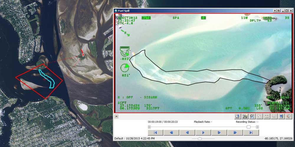
- FMVsea – An application that uses Esri Full Motion Video (FMV) technology to fuse navigation data with video imagery collected using aerial and submarine camera systems. CSA will provide demonstrations of how we use FMVsea to extract geospatial information from video, including a rapid estimate of the spatial extent of a fuel spill on the surface ocean, a technique that can revolutionize oil spill response and dispersant monitoring.
- seaApps – Mobile, web, and desktop applications to collect, process, report, and manage environmental data.
- seaData – Services to enable the discovery, integration, quality assurance, and curation of data. CSA will demonstrate the use of data to convey environmental baseline conditions, identify resources at risk, process and display real-time feeds, and leverage publicly available information on the web – all crucial elements of spill planning and response.
“CSA offers Environmental Data and Geospatial Services to provide our clients with data visualization and analysis capabilities that enable them to make informed and timely decisions, which are elements crucial to effective project management and incident response,” said Dr. Jodi Harney, manager of CSA’s EDGS program.
Dr. Harney will also present “Feeding a COP: Providing Premium Environmental Content to a Common Operating Picture” in the Situational Awareness session on Wednesday, 11 November. She will discuss the use of EDGS applications in oil spill planning, spill drills, and actual incidents, including the consumption of environmental data layers by a Common Operating Picture.
Visit CSA’s booth #321 to learn more about EDGS applications and see demonstrations.
Corporate Headquarters
8502 SW Kansas Ave.
Stuart, FL 34997