CSA Completes GIS Model to Guide Seagrass Restoration in the Indian River Lagoon, Florida
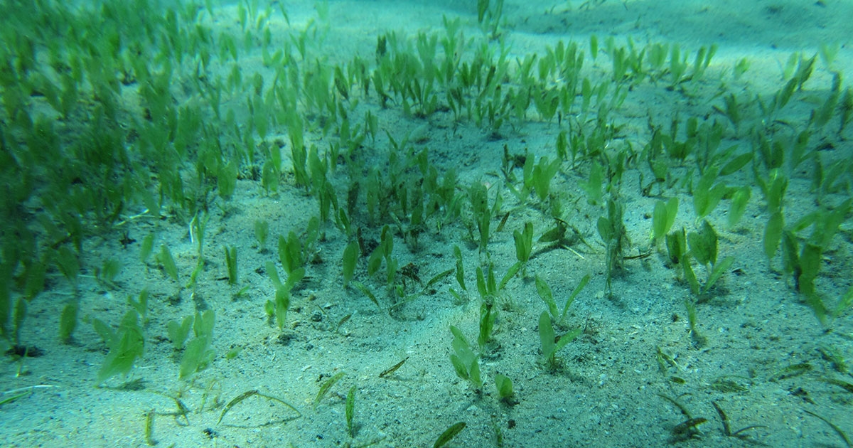
Seagrass beds provide a high level of ecosystem services; from balancing water quality to carbon storage to supporting fisheries, seagrass communities are the foundation of coastal regions like Florida’s Indian River Lagoon (IRL). In an effort to increase seagrass coverage and prevalence throughout the IRL, local and state governments, NGOs, and universities have begun the practice of seagrass restoration and transplanting, but it can be a tricky task.
Seagrasses in the IRL are impacted by many environmental variables and understanding how all those variables work with each other is important. As concerted conservation and restoration efforts in the IRL continue to ramp up, so does the need for informed and reliable tools. To improve seagrass restoration success, Brevard County sought out CSA Ocean Sciences Inc. (CSA) to develop a seagrass restoration risk assessment model to guide their efforts and promote successful outcomes.
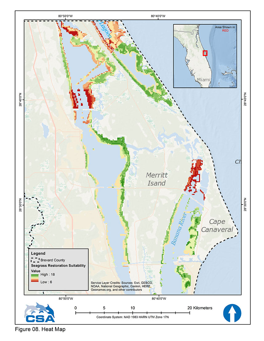 Figure A: Heat map showing final total suitability values for seagrass transplantation site selection for the north range (from north to south) of the Indian River Lagoon segments within Brevard County, Florida. A suitability value score of 6 = lowest suitability (highest risk) environment ranging up to 18, indicating the most suitable (lowest risk) environment. Any geographic location without representation in the color ramp has a suitability value less than 6 and is excluded from recommendation for seagrass transplantation.
Public Risk Assessment Tool
To guide seagrass restoration efforts, CSA, contracted under EAI, collaborated with scientists in Brevard County Natural Resources Management and St. Johns River Water Management District (SJRWMD) to develop a geospatially registered risk assessment model in ArcGIS for Brevard County to employ. Estuarine environmental variables—provided by SJRWMD, Applied Ecology under contract with Brevard County, and CSA—were used to determine the feasibility for seagrass survival. Salinity, temperature, chlorophyll, dissolved oxygen, bathymetry, and past seagrass distribution data were all considered when determining the relative risk for seagrass restoration. Environmental data for each variable were divided into levels of risk and assigned risk rankings. The sum of risk rankings for all variables was output by the model to help inform restoration decisions. Risk rankings ranged from 6 (High Risk – Low Suitability) to 18 (Lowest Risk – High Suitability; see Figures A, B, and C for an application of the model running north to south through Brevard County.
This model—which CSA hopes to adapt for use by other resource managers—shows those contemplating seagrass restoration in the IRL where success can be more challenging and prompts practitioners to avoid the footprints of existing long-term studies. While the risk assessment does not indicate where seagrasses can or cannot survive, it does show where multiple factors combine to indicate an increased risk of restoration failure.
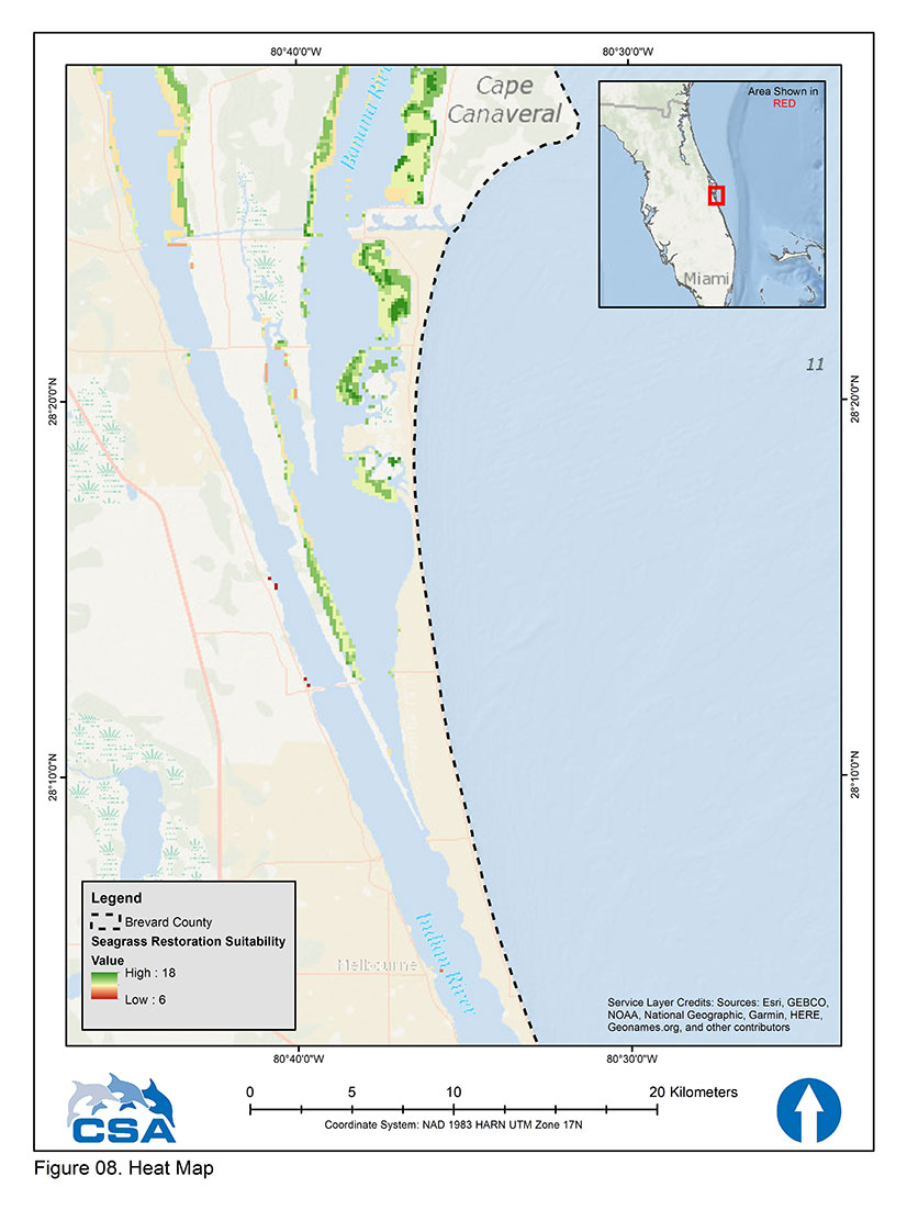 Figure B: Heat map showing final total suitability values for seagrass transplantation site selection for the middle range (from north to south) of the Indian River Lagoon segments within Brevard County, Florida. A suitability value score of 6 = lowest suitability (highest risk) environment ranging up to 18, indicating the most suitable (lowest risk) environment. Any geographic location without representation in the color ramp has a suitability value less than 6 and is excluded from recommendation for seagrass transplantation.
“The risk assessment model should guide seagrass restoration practitioners to tamper efforts in areas of increasing risk,” says lead author Dr. Mark Fonseca, Chief Sciences Officer at CSA. “Outside of just the model, a ‘Plan-Act-Monitor-Learn’ cycle of management was also developed, in which seagrass transplants are placed in experimental units and tested based on a series of scientific questions.”
To foster adaptive management, the model can be upgraded over time with updated or additional ArcGIS data layers for water quality, bathymetry, other environmental data, or restoration-success data to improve overall risk forecasting for seagrass restoration projects.
A Model for Future Success
GIS-based risk assessment models, such as this one, are a new way of organizing quantitative environmental data into direct restoration guidance.
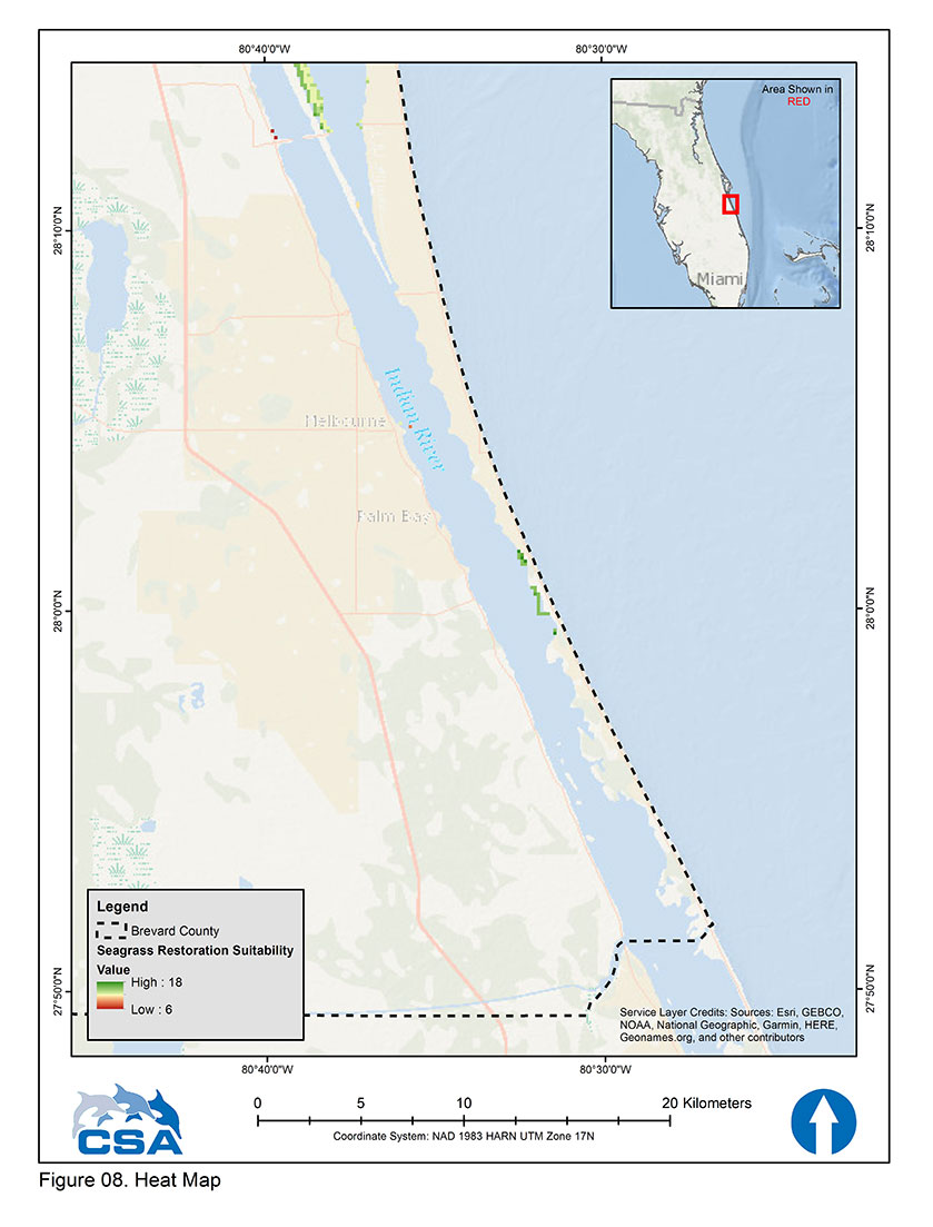 Figure C: Heat map showing final total suitability values for seagrass transplantation site selection for the south range (from north to south) of the Indian River Lagoon segments within Brevard County, Florida. A suitability value score of 6 = lowest suitability (highest risk) environment ranging up to 18, indicating the most suitable (lowest risk) environment. Any geographic location without representation in the color ramp has a suitability value less than 6 and is excluded from recommendation for seagrass transplantation.
Ms. Virginia Barker, Director of Natural Resources Management for Brevard County, adds, “This seagrass restoration tool supports a science-based decision-making process for practitioners and managers to minimize risk and improve the likelihood of project success. Not only does this risk assessment model provide guidance using the best available current data, but its web-based platform allows new or updated geospatial data layers for variables of interest to be incorporated making this an adaptive, customizable, and easy to access tool for any restoration project.”
The approach of developing customizable and fluid ArcGIS models allows for data to be highly transferable and can be applied to any ecosystem where there are geospatially articulated and available data representing critical factors that limit living resources.
Find out more about CSA and our risk assessment services.
Corporate Headquarters
8502 SW Kansas Ave.
Stuart, FL 34997