CSA completes mapping for Tampa Bay Estuary Program
CSA Completes Large-Scale Hard Bottom Mapping Effort for the Tampa Bay Estuary Program
CSA Ocean Sciences Inc. (CSA) recently completed another large-scale mapping effort to identify and characterize hard bottom substrate in Tampa Bay utilizing a combination of side‑scan sonar and high definition drift video.
Hard bottom habitats in Tampa Bay are protected submerged habitats under state and federal wetland regulations and are also considered an essential fish habitat for different life stages of various fish species, including several of commercial and recreational importance. These habitats are relatively rare and sparsely distributed throughout the Bay, and, up until recently, knowledge was limited as to their specific location. In order to improve our knowledge of these important habitats, the Tampa Bay Estuary Program (TBEP) initiated a project to locate, characterize, and create finer-scale thematic maps of hard bottom in a section of Tampa Bay, building upon work previously done.
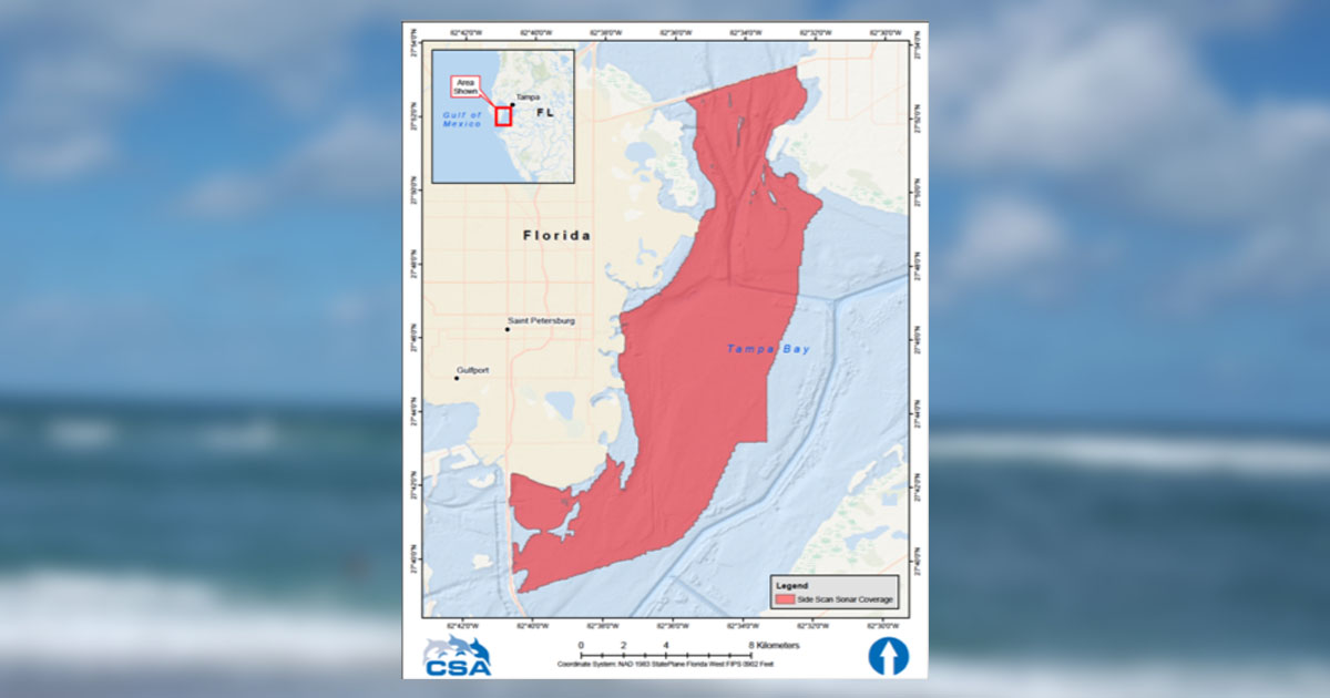
Starting in July 2018, CSA and its hydrographic survey sister company Morgan & Eklund performed an initial 34 days of field collection utilizing side-scan sonar to capture over 55 square miles of Bay bottom. CSA Geographic Information System (GIS) specialists then reviewed and interpreted the data to delineate hard bottom and potential hard bottom areas from regions of unconsolidated mineral substrate (i.e., areas of sand and mud bottom), utilizing a combination of SonarWiz and ArcGIS software. Following the digital delineation of these areas, ground-truthing locations were selected and approved by TBEP. Using a drift video camera system, the CSA field team collected geo-referenced vertical and oblique video footage at 307 ground-truth locations in December 2018. Video imagery was analyzed to verify initial substrate delineations and characterizations.
CSA GIS specialists integrated ground-truthing observations and substrate delineations to create a comprehensive thematic map. Hard bottom areas were classified based on the National Oceanic and Atmospheric Administration (NOAA) Coastal and Marine Ecological Classification Standards (CMECS). The final thematic map and report were provided to TBEP in August 2019.
“Tampa Bay is such an important ecological resource,” said Ed Hughes, CSA project manager for the effort. “It plays a vital role in local and state economies and contributes to the quality of life for the local community as a whole. To be involved in a project like this was a privilege, and working directly with the experts at the Tampa Bay Estuary Program was a terrific opportunity – the Bay is in great hands under their stewardship.”
This is the second major hard bottom mapping effort that CSA has conducted in Tampa Bay. In 2015, CSA teamed with SurvTech Solutions and AIM Engineering & Surveying to collectively map and interpret over 57 square miles for the Southwest Florida Water Management District. With some other additional smaller-scale projects, CSA has now been involved in mapping 110 square miles of the seafloor and have identified over 245 acres of hard bottom within the Bay.
In addition, the maps and reports created by these studies have already provided assistance to other state agencies. The Florida Fish and Wildlife Conservation Commission (FWC) has been using the mapped hard bottom locations as part of their sampling universe for their innovative hard bottom fish survey program, utilizing baited remote underwater video cameras to identify and count fish species associated with these habitats. They have even identified some fish species that had not been previously documented within the Bay.
The final report is available on the TBEPs technical website: Tampa Bay Hard Bottom Mapping Project, TBEP Technical Report #08-19. Project funding was provided by the Tampa Bay Environmental Restoration Fund, Pinellas County, the Environmental Protection Commission of Hillsborough County, the National Fish and Wildlife Foundation, and the TBEP.
Corporate Headquarters
8502 SW Kansas Ave.
Stuart, FL 34997
Recent Blogs
- Supporting the Realization of Sustainable Energy at the Caribbean Sustainable Energy Conference 2024 Jun 24, 2024
- CSA Provides Planning and Field Support for First Carbon Sequestration Ocean Experiments by Gigablue® May 16, 2024
- PSO Reports Prove Fruitful for Environmental Impact Assessments Apr 15, 2024