-Bridge-shading-model-results,-Emerald-Isle,-NC_large.jpg)
Demand for Marine Geospatial Analytics and Modeling Services Continues to Grow as Ocean Exploration Expands
According to a recent market report published by Fortune Business Insights, the global geospatial analytics market is projected to grow from $63.61 billion in 2021 to $147.58 billion by 2028; a growth rate of 12.8% in the forecast period.
Growth on this scale is being driven, in no small part, by current advances in geospatial technologies, such as geographic information systems (GIS), satellite imagery, and global navigation satellite systems. Further, with the increased integration of smart technologies—AI-fused systems designed to acquire previously unthinkable volumes of data under the watchful eye of the Internet of Things (IoT)—our collective ability to process and analyze multiple and often complex data sets with increasing accuracy and reliability has nudged us into a new era of practical geospatial analytics.
Somewhat predictably, the range of end-users of geospatial analytics continues to broaden, from defense operators to logistic providers and from energy developers to scientific institutions. It is no surprise, then, that as society seeks to establish robust and forward-looking plans to sustainably explore our oceans, demand for geospatial analytics and modeling services is at an all-time high from coastal and offshore project teams. Virtually all marine surveys are now designed in a spatially defined framework, with sample points defined in advance, often with high resolution, in an appropriate GIS platform.
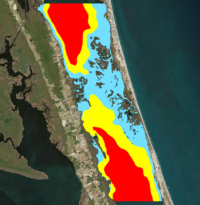
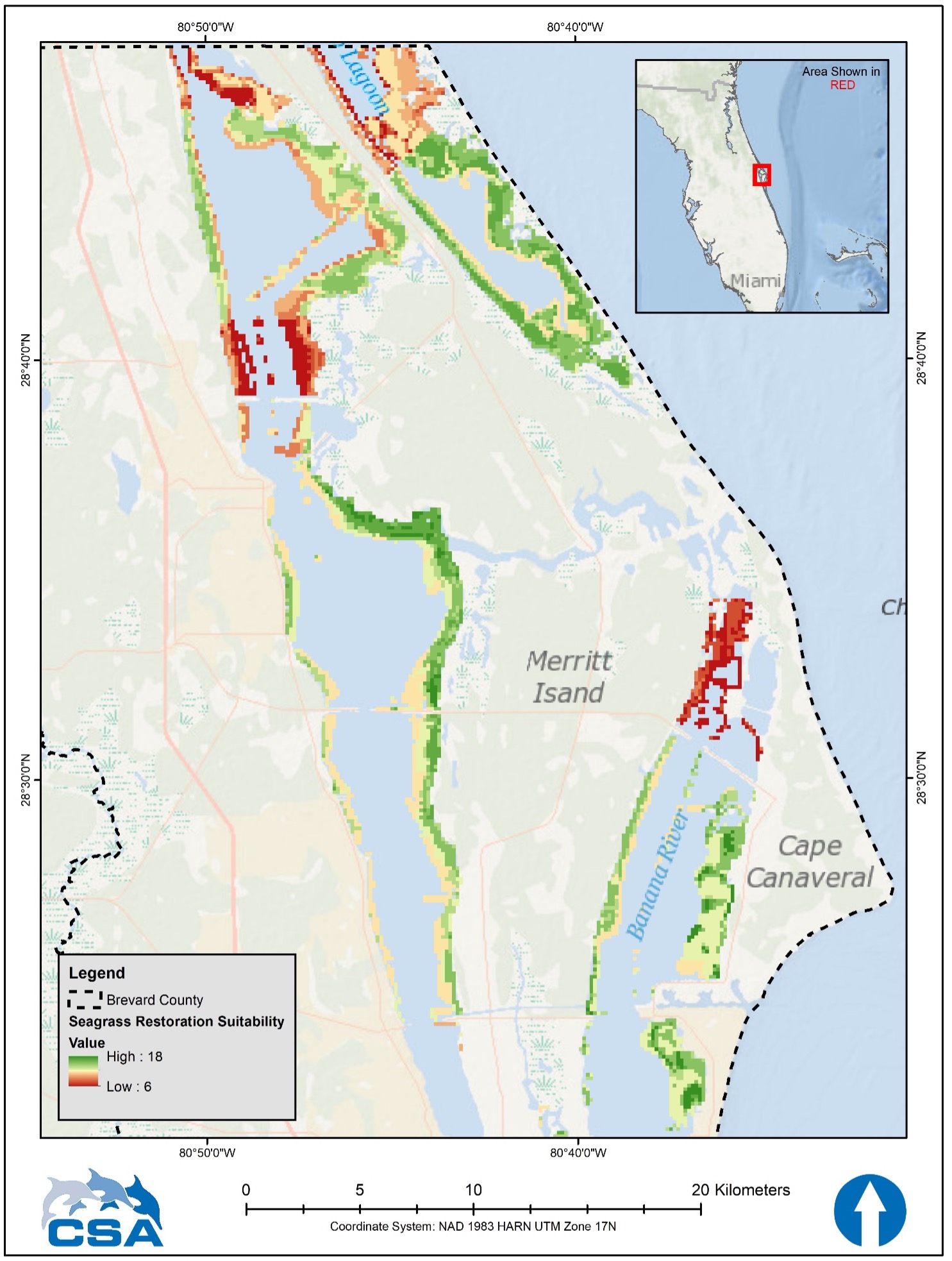 Seagrass suitability model, Cape Canaveral, FL
Moreover, synoptic and spatially articulated data collected by aerial- and satellite-borne sensors provide the base information for any manner of physical, chemical, and biological phenomena as well as context for survey design, interpretation of survey information, and layout of coastal development projects. Given this broad availability of geographic data sources, spatially explicit models are developed and applied in virtually all avenues of scientific investigation, particularly for the environmental and ecological sciences.
In keeping with this rapid and ongoing evolution of geomatics, CSA Ocean Sciences Inc., (CSA) uses state-of-the-art programs (e.g., Esri, QGIS, R, SAS, and Python applications) to work with clients to create novel model solutions needing a geographically defined context. With CSA’s broad scope of services, the topics of these models vary widely. Currently, CSA provides modeling services in five general categories.
Marine Sound – use of the National Oceanic and Atmospheric Administration (NOAA) Calculator and application of dBSea software designed especially for, but not limited to, an impact assessment from artificial sound sources. CSA routinely teams with underwater acoustic specialists to provide the entire range of marine acoustic assessments, including use of the NOAA Calculator (Technical Guidance for Assessing the Effects of Anthropogenic Sound on Marine Mammal Hearing).
 Wave Exposure Regime, Currituck Sound, NC
Environmental – CSA creates or applies these and other customized tools for our clients to provide predictive modeling solutions:
- Marine Mammal Vessel Strike Risk: Developed by CSA for the Bureau of Ocean Energy Management (BOEM), this GIS-based model predicts the number of encounters between vessels and marine mammals and turtles during vessel transits and allows users to test and compare scenarios of marine mammal and reptile strike risk. (CSA Development Product)
- Seagrass Restoration Risk Assessment: Developed by CSA for Brevard County, Florida, this model uses the ArcGIS Pro tool—Suitability Modeler—to create risk maps using water quality, bathymetry, and seagrass persistence to assess the risk of potential locations for seagrass restoration. (CSA Development Product)
- WEMo: A GIS-based wind-wave forecasting tool developed by CSA staff under a previous affiliation with NOAA. This highly accurate tool works in protected waters (not open ocean) and provides wave heights, energy, and seafloor scour forecasts. (Co-developed by CSA staff)
- Bridge Shading Tool: A proprietary, GIS-based tool developed by CSA for the North Carolina Department of Transportation (NCDOT) to forecast the spatial distribution of shading from objects over time, especially bridges, to help guide habitat impact assessment and mitigation strategies. (CSA Development Product)
Parametric and Nonparametric Statistics – CSA excels in the application of both parametric and nonparametric statistical models and, importantly, the accompanying pre-campaign development of valid, efficient, and defensible survey and experimental designs. CSA designs surveys and analyzes data collected during field projects with linear, generalized linear, or multilevel models as appropriate. CSA is also highly experienced in distance- and model-based multivariate analyses of species abundance or presence-absence versus measured environmental variables.
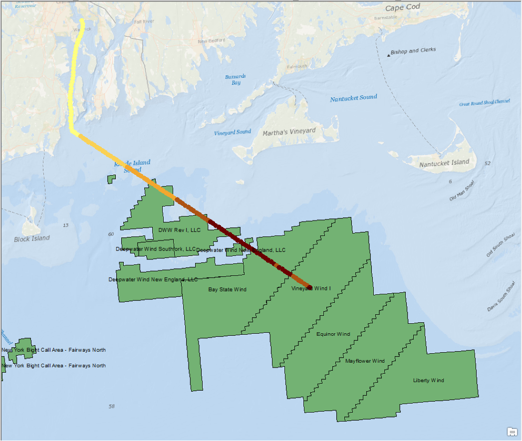 Marine mammal strike probability map for vessel path, offshore RI
Geostatistics – This is a specialized branch of statistics, providing analysis and important spatial and spatiotemporal prediction of environmental parameters. CSA uses geostatistics to both guide the scale of sampling independence but also to develop large, field-based statistical response surfaces against which subsequent sampling can be tested, providing clients with an efficient and flexible future sampling framework, especially when the time and location of future sampling stations are not yet known.
Natural Resource Damage Assessment – CSA utilizes Habitat Equivalency Analysis (HEA) (including both “Visual HEA” and customized versions) as well as Florida’s Unified Mitigation Assessment Method (UMAM). Both HEA and UMAM calculate mitigation acreages for Federal and State regulatory processes, accounting for recovery times and various approaches to service discounting. It is clear that geospatial analysis, statistics, and modeling will continue to bring data-led clarity to operations in notoriously complex environments. CSA’s multifaceted approach to the modeling of marine environments, defined by our five general categories, empowers the broad ocean community—scientists, governments, developers, and technologists alike—to optimize the utility of applied statistics and geospatial data in their decision making. CSA, as a comprehensive marine environmental services provider, is on hand to partner with clients to provide these custom services and novel solutions for their marine environmental assessment and management needs worldwide.
Corporate Headquarters
8502 SW Kansas Ave.
Stuart, FL 34997